

Index:
- What is LiDAR and why does it matter?
- How does LiDAR work?
- Which industries use LiDAR?
- What are the advantages, limitations, and implementation considerations?
- What is the strategic value of LiDAR technology?
Your physical-world data is probably less accurate than you think. Whether you are managing critical infrastructure, deploying autonomous systems, or running large-scale environmental programs, the quality of your physical-world data determines how fast and how confidently you can act. LiDAR is the technology redefining that standard and enterprise adoption is accelerating. Here is what you need to know.
What is LiDAR and why does it matter?
Light Detection and Ranging (LiDAR) is a remote sensing technology that creates precise, three-dimensional maps of the physical environment using laser light.
For enterprise teams, LiDAR technology replaces slow, manual, and error-prone survey methods with automated, high-density spatial data collection. It captures millions of data points per second remotely with centimeter-level accuracy. That combination of speed, scale, and precision makes it foundational to infrastructure planning, autonomous systems, environmental monitoring, and asset management.
Unlike GPS or photogrammetry, LiDAR operates in low light, penetrates dense vegetation to map what lies beneath, and covers vast areas in a single acquisition pass. For teams managing large assets or complex terrain, this is not a marginal improvement; it is a fundamentally different capability.
How does LiDAR work?
LiDAR works by emitting laser pulses from a sensor, recording the time it takes for them to return after hitting an object, and converting that time-of-flight data into precise distance measurements that form a 3D point cloud.
The LiDAR system combines a high-frequency laser scanner (that emits hundreds of thousands of pulses per second toward the target area) with GPS and motion sensors to precisely locate each laser pulse in three-dimensional space.
System configurations: Airborne LiDAR mounted on aircraft, drones, or helicopters and includes topographic LiDAR (land elevation) and bathymetric LiDAR (maps seafloor and riverbed elevations through water). Terrestrial LiDAR mounted on vehicles or fixed tripods for infrastructure inspection, building scanning, and corridor mapping.
Data output modes: Full-waveform LiDAR records the entire reflected pulse, delivering millimeter-level accuracy. Preferred for forestry, precision engineering, and environmental modeling. Discrete LiDAR captures only peak return intensities. Faster to process and better suited for large-scale commercial mapping, where throughput matters more than maximum resolution.
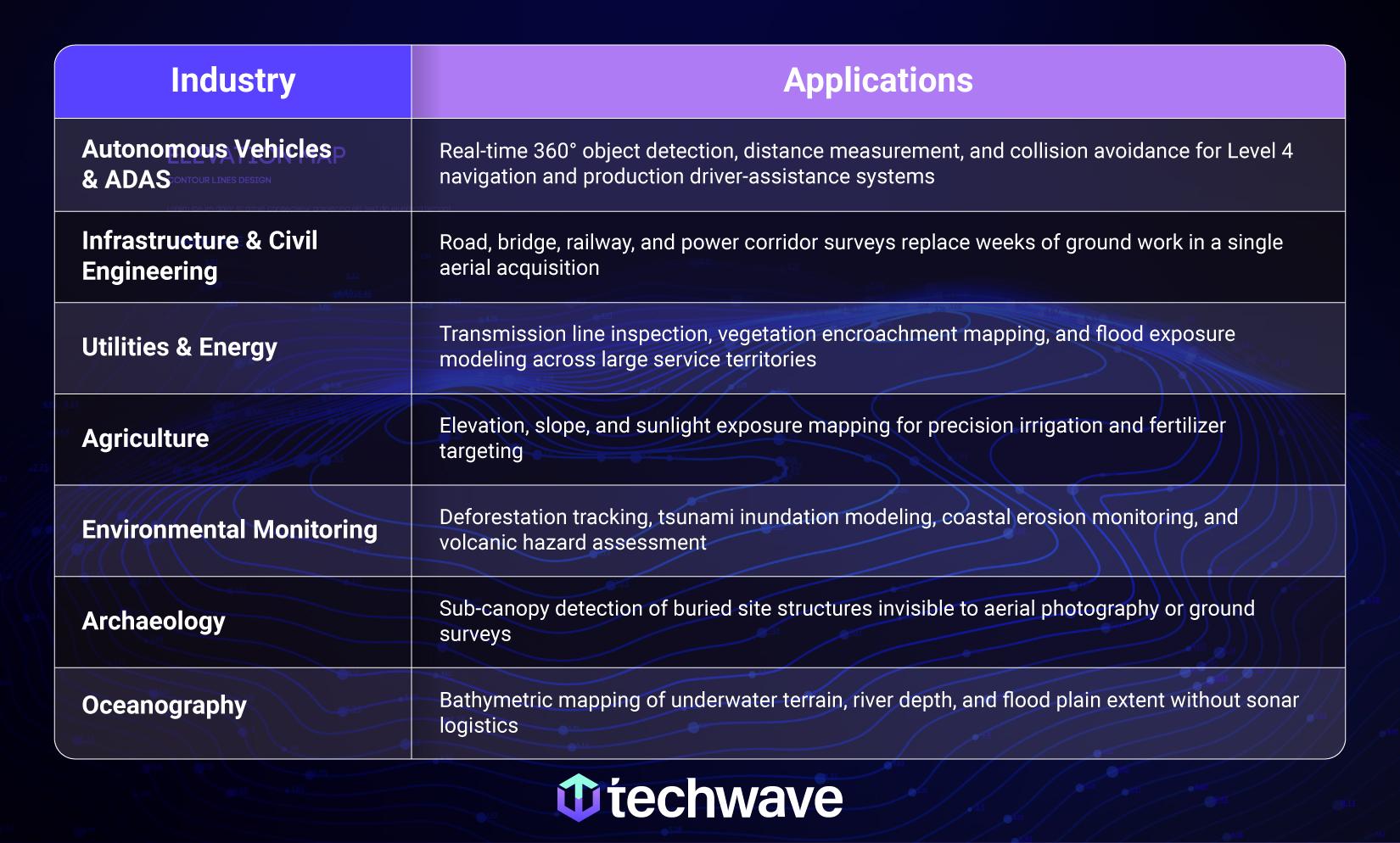
Which industries use LiDAR?
LiDAR solutions are deployed across any industry where spatial accuracy, coverage, or remote data collection determines operational outcomes.
What are the advantages, limitations, and implementation considerations?
Advantages
- Operates day and night, with no dependence on ambient light
- Covers large areas in a single pass, significantly reducing field time and labor costs
- Reaches hazardous or inaccessible environments without putting field teams at risk
- Produces point cloud data dense enough for volume calculations, 3D modeling, and terrain analysis at resolutions GPS or photogrammetry cannot match
Limitations
- Hardware costs for full-waveform and high-density aerial systems remain higher than alternatives, though prices are declining as solid-state technology matures.
- Raw point clouds from a single campaign can exceed hundreds of gigabytes, requiring significant storage, processing infrastructure, and skilled personnel.
Considerations
- No single international standard governs LiDAR data quality. The ASPRS Positional Accuracy Standards (updated in 2024) are the de facto benchmark for most US projects, but emerging ISO standards and application-specific frameworks (automotive, defense) also exist. Do not assume defaults apply; explicitly specify the accuracy requirements for your use case.
- Laser eye-safety protocols require active management for all ground-based deployments.
- Engage an experienced implementation partner early to avoid misalignment between sensor configuration, data format, and downstream platform requirements.
Precision determines performance
Our experts can help you deploy LiDAR that meets your accuracy, budget, and timeline requirements.
Talk to a Techwave SpecialistWhat is the strategic value of LiDAR technology?
LiDAR delivers measurable ROI by replacing high-cost, manual survey programs with faster, more accurate, remote data collection at a fraction of the field labor cost and time. The global LiDAR market is forecast to grow from USD 3.53 billion in 2026 to USD 17.80 billion by 2035, at a CAGR of approximately 20%.
For utilities managing thousands of kilometers of transmission infrastructure, a single LiDAR campaign replaces years of incremental ground surveys while producing higher-quality data for vegetation management, regulatory reporting, and capital planning. For autonomous vehicle programs, LiDAR is the enabling sensor for safe navigation at scale.
Organizations that act now build a data and operational advantage that compounds over time. In spatial intelligence, early movers set the standard everyone else follows.

Top 5 Questions Answered in This Blog
- What is LiDAR and how does it work?
- How does LiDAR penetrate dense vegetation to map what lies beneath?
- What are the advantages and limitations of LiDAR technology for businesses?
- How does LiDAR improve safety by reaching hazardous environments without field teams?
- What is the projected growth of the global LiDAR market and why?
