

Why high-integrity GIS data is now mission critical for utilities?– by Santosh Reddy Patlolla, Director, Engineering Services-Utilities
Modern Electic utilities rely on high-integrity network data to operate reliable grids. Inaccurate or misaligned data slows outage response, weakens planning, increases costs, and raises regulatory risk. Yet many utilities still manage business-as-usual (BAU) data through fragmented workflows across fields, enterprises, and operational systems. At the center is the geographic information system (GIS), the authoritative network model for real-time operations.
Techwave’s Integrated Support Model (ISM) transforms routine GIS updates into a governed, enterprise capability that ensures alignment, integrity, and operational confidence.
The Role of GIS in Aligning ERP, EAM, and ADMS
GIS acts as the authoritative network model that feeds all core systems.
- ERP uses GIS data to track asset cost and financial accountability.
- EAM relies on it to manage maintenance history, condition, and replacement cycles.
- ADMS depends on accurate GIS connectivity and topology to run real-time grid operations.
To ensure reliable operations, utilities must:
- Keep spatial and connectivity data current
- Maintain alignment across GIS, ERP, EAM, and ADMS
- Sustain network models with operational-grade rigor
Why Business-as-Usual as a Reliability Advantage?
Reliability is built through everyday operations, not only during outages. BAU activities, such as new connections, inspections, and repairs, continuously change the network. When these changes are accurately captured in the GIS, the digital network remains aligned with the physical grid.
High-integrity BAU data maintenance ensures:
- A trusted network model Integrated Support Model for operational systems.
- Accurate switching and restoration decisions in advanced distribution management systems.
- Confident maintenance and investment planning in enterprise systems.
- A single, consistent network view for field and control room teams.
Traditionally treated as a back-office task, BAU data maintenance is now a strategic advantage in reliability.
Why BAU Must Change?
In modern utility environments, traditional BAU data maintenance introduces operational gaps, such as:
- Risk: Missed GIS updates after field changes lead to incorrect network connectivity, delaying outage isolation and restoration.
- Cost: Incomplete asset data surfaces during audits, triggering expensive backlog cleanup from surveys or LiDAR rework.
- Trust: Repeated data mismatches force teams to rely on spreadsheets instead of system data.
How Techwave mitigates this:
- Rapid geospatial updates with automated validation.
- Embedded quality checks and standardized workflows.
- Governance-driven synchronization across systems.
Without structured, operational-grade maintenance, these gaps grow over time and steadily weaken reliability.
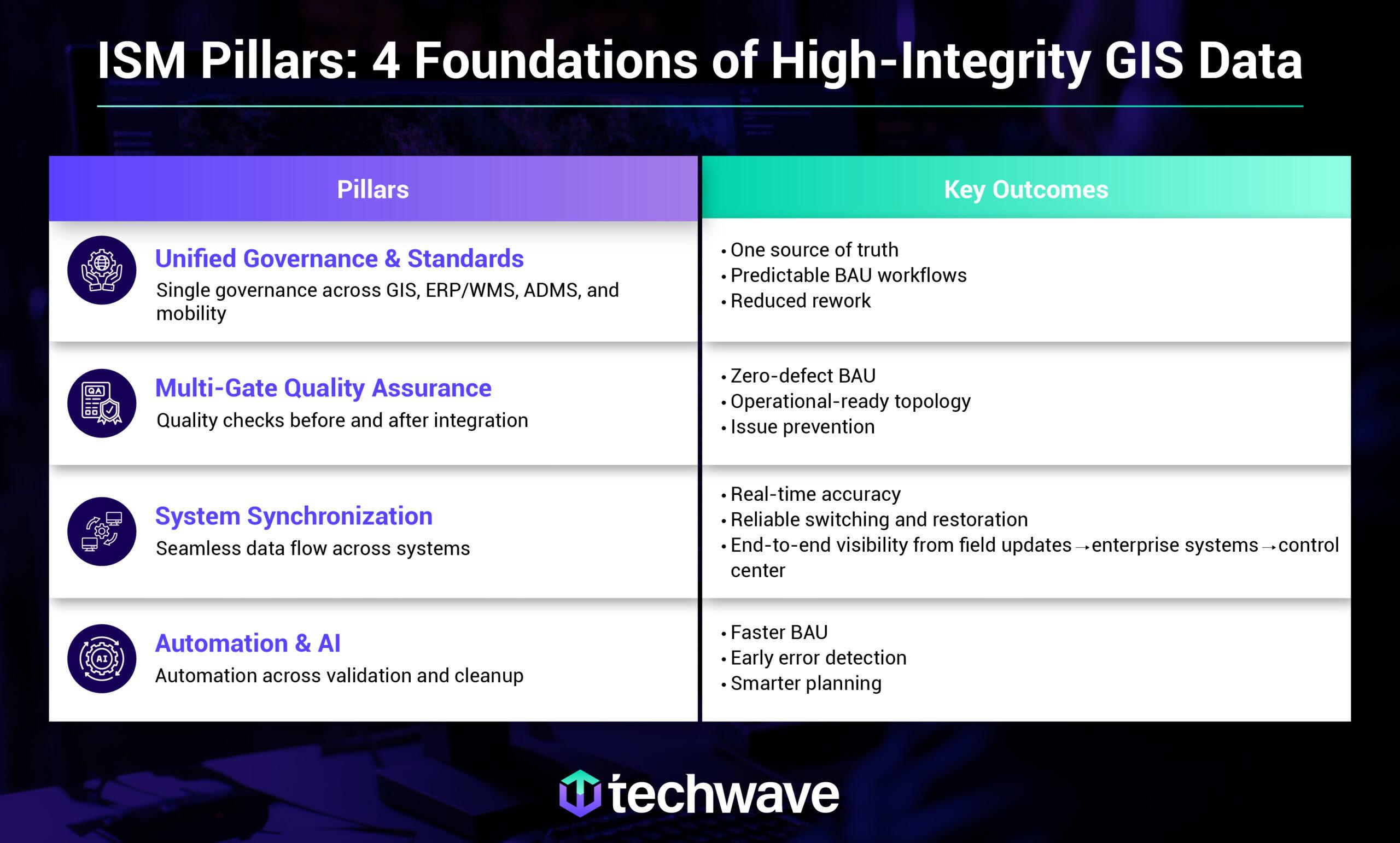
What Techwave’s Integrated Support Model (ISM) Is?
Techwave’s is a structured framework that transforms GIS data maintenance into a scalable, governed operation. It unifies:
- People: Utility-focused delivery teams with domain expertise
- Process: Standardized workflows for consistent execution
- Governance: Enforced standards, naming conventions, and data models
- Automation: Embedded quality checks and synchronization
The ISM Framework is Built on Four Important Pillars.
End-to-End BAU Data Flow
Every field change is first updated in the GIS to reflect real network conditions. Validated data is then synchronized with enterprise and operational systems to support daily operations.
This ensures:
- Accurate, trusted network data
- Consistency across systems
- Faster, safer operational decisions
Techwave’s ISM framework enables this controlled, reliable data flow.
Team Balance Model — Aligning Work to Skill Pods
Techwave structures delivery teams to balance operational demand and quality. Work is mapped to dedicated skill pods covering:
- Emergency updates
- Priority changes
- Data maintenance
- Quality assurance
Why this team balance works:
- Prevents bottlenecks by separating urgent and routine work
- Ensures data quality maintenance even during high-volume periods
- Supports 24/7 operational readiness
- Reduces error risk by aligning work to expertise
Techwave delivers GIS data maintenance for utilities.
AI & Automation: Detect → Prevent → Optimize
Techwave integrates AI solutions for utilities to shift from reactive to proactive maintenance.
- Detect: AI identifies anomalies between satellite imagery and GIS records.
- Prevent: Automated validation checks stop broken connectivity from being published.
- Optimize: Predictive analytics suggest optimal maintenance cycles.
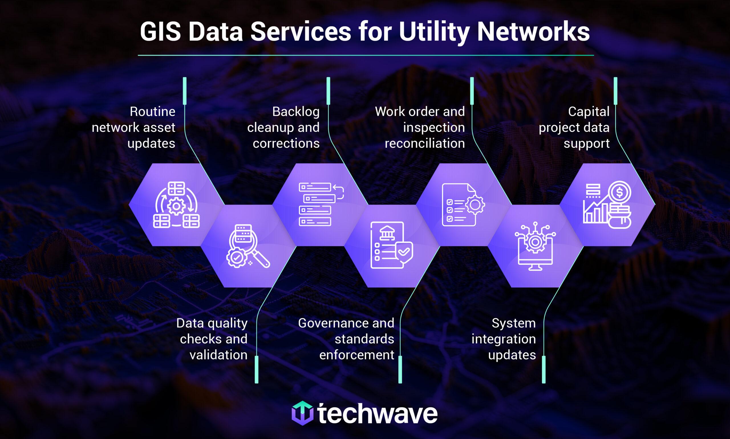
Utility Use Cases Enabled by High-Integrity GIS Data
- New Connections: Simplified Engineering Services for rapid FTTH or grid expansion.
- Outage/Restoration: Reliable ADMS feeds for faster fault location.
- Lifecycle Planning: Accurate EAM data for long-term asset health.
- Inspections: Leveraging AI-Driven Predictive Maintenance to identify at-risk assets before failure.
KPIs & Reporting: Transparency in Quality
We provide a weekly and monthly cadence of reporting, focusing on:
- Throughput: Volume of emergency vs. BAU updates.
- Accuracy: Percentage of records passing first-time quality gates.
- Timeliness: Average “Field-to-GIS” cycle time.
This rigorous measure ensures that data remain operational-grade, supporting safe and reliable decision-making.
Why Techwave
With over 20 years of experience and a global footprint, Techwave is more than a service provider; we are a partner in utility modernization. Our ISM framework ensures that your GIS remains the “Single Source of Truth,” empowering a smarter, greener, and more resilient grid.
So, connect with Techwave to turn everyday data into a strategic advantage.